The company participated in MariMatch as part of the Posidonia 2018 International Exhibition. The event, organized by the National Documentation Center and the Enterprise Europe Network, concerned the networking of organizations (SMEs, Research Centers, clusters etc.) through scheduled 30-minute appointments. Discussions focused mainly on partnerships in financing, product and service promotion, research and innovation promotion, etc.

The main areas of the event were (●) shipbuilding, (●) green shipping, (●) electronic, communication and navigation, (●) mechanical and auxiliary systems, (●) maritime services, (ασφάλεια) maritime safety and special equipment , (●) marine research, development and innovation and (●) marine bioeconomy.

The company participated in the Technology Forum 2018 Matchmaking Event (https://technologyforum2018.b2match.io/), held on Wednesday, May 16th in Thessaloniki (KEDEA AUTH Building)

The purpose of the event was to develop an active platform for seeking business, technological and research collaborations. Participants had the opportunity to expand their network of contacts, explore new ideas and develop IT collaborations, following a pre-defined meeting schedule. The event focused on the broad field of information and communication technologies involving key areas, as well as applications in medicine, transport, environment, energy, education and more.

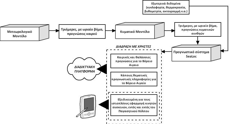
The SeaLoc project aims to create an integrated system of forecasting and accompanying services for the Greek seas that will provide users with interaction, both through the internet and social media, as well as through specialized applications, the results of which will be readily exploited by target groups (eg companion applications to existing platforms such as incrediblue, tripinview, all4yachting, dockit, marinetraffic, amola, tripadvisor, booking, trivago, airbnb etc. and mobile applications).


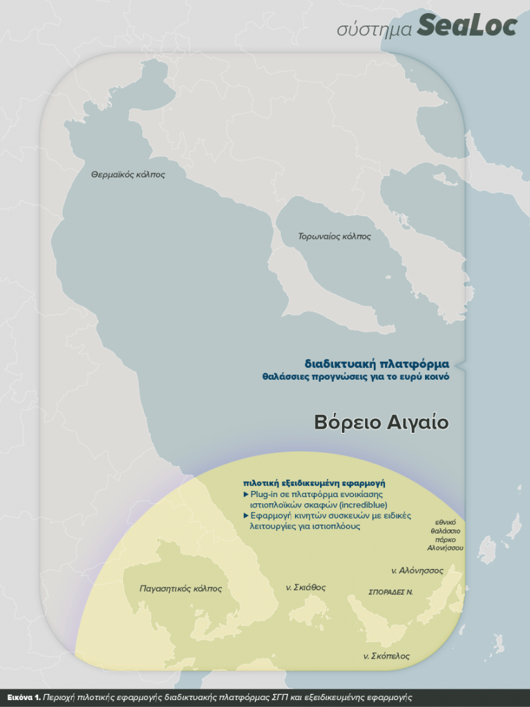
These applications will be tailor-made, at very high temporal and spatial resolution, and will include in addition to widespread sea-level forecasts (wind, wave, current, temperature) and specific thematic indicators (for example, degree of distress, ease bathing, blurring, point-to-point guidance, etc.) as well as customized functions that will be developed and delivered based on the identified and recorded needs of specific target groups (tailor-made and on-demand services). Pilot implementation of the system will take place in and off the Pagasitic Gulf, specializing in sailing activities, while general forecast information and thematic forecasts will be provided for the entire North Aegean.


For the first time in Greece, a private sector partnership will be able to capitalize on the scientific knowledge it has accumulated to provide high value added services in coastal weather and marine forecasting.

Project Budget

The drafting and ratification of forest maps is a high priority on the one hand for our Constitution and on the other for a modern country that needs to know where, how much and what public and private property is. Two hundred years after the liberation of the Greek state and these issues have not yet been resolved. Today, we are called upon to solve them, through the evolution of things, which have inevitably created another situation.

So the forest charts do not create problems, but they bring them up and, based on the tools available in the legislation, citizens come to solve them, which of course are solved.

Our farmers, on the other hand, have for years been cultivating and subsidizing land that is doubtful in both form and ownership status. These issues mainly concern two categories of forest map. Arable land plowed sometime after 1945 (PA) and forested land after 1945 (PA), ie abandoned by their owners.

It also addresses most of the issues for Greek producers who, for the areas where we now have a forest map, should take appropriate action if they want to continue to receive subsidies for these areas, ie either the acquisition / change of use request. or for the objection / submission to Article 67 for forested areas.

However, this is not the case in areas where we already have a partially ratified forest map. In these, and if the owner-producer has not done the previous actions, then by August 2018 he / she only has the option of filing a takeover / change of use application in order to receive his / her subsidies normally.

Non-action on the part of producers or owners (Grade A and Grade A) mathematically leads to these areas being ineligible, with multiple negative consequences both for themselves and for our country, namely the loss of subsidized income to the producer, permanent loss of land eligibility for the country, possible retroactive charges, etc.

The solution is once again passed by the political leaderships of the Ministry of Environment and Physical Planning and the RIS and it is the activation of the first and second level Local Authorities, who, as owners of the plots, must do the right thing, that is, to do the foreseen actions. If additional resources are required for this, the state must assist the Local Authorities so that they can take all necessary actions.

Settling issues related to forest maps and livestock aids, however, also creates business opportunities to develop application-services that facilitate citizens, and in particular Greek producers and owners.

These solutions must be reliable and personalized that, through simple and automated procedures, ensure payment of the corresponding agricultural aid and create the best conditions for the problems to be finally resolved.

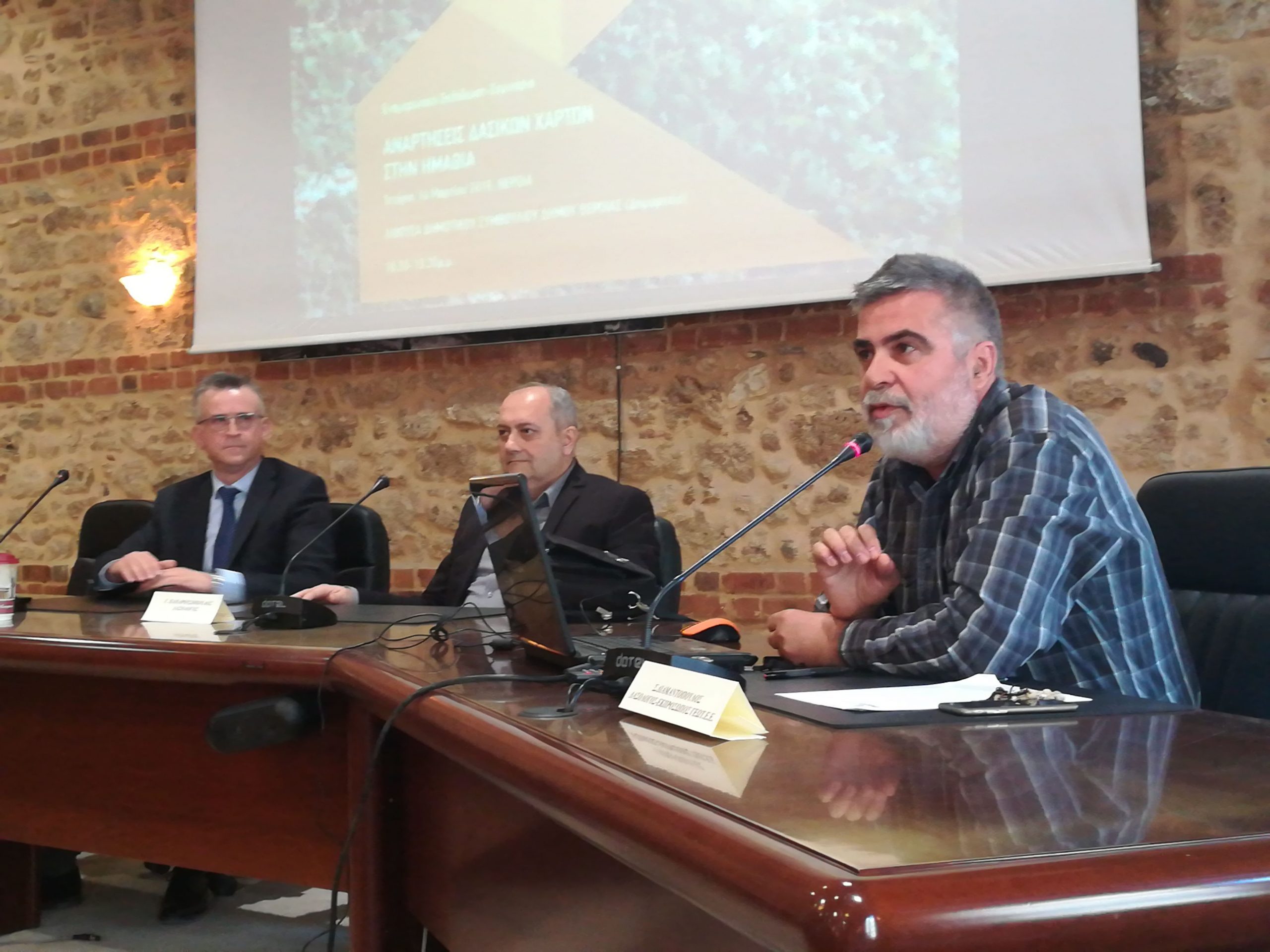
Mr. Stergios Diamantopoulos, as a representative of GEOTE, participated in the event which was jointly organized by the Technical Chamber of Greece - Department of Central Macedonia, the Chamber of Geotechnics - Central Macedonia Branch and the Lawyer's Association .

At the event, the public had the opportunity to learn about the importance of Forest Map postings, the characterizations of the map and the tools available so that the citizen or body can safeguard their property and property.

bst

On Tuesday 6/3/2018, the informative presentation of the agroforestry land application was successfully held at the Porto Palace Hotel in Thessaloniki organized by Omikron SA. together with GAIA Business.

It is a decision-making advisory service, which will inform the producers concerned on any possible overlap that their parcels may present with the forest map, on the other hand will propose and execute a series of actions that producers can take, so that they can continue their agricultural use and not lose any or all of their agricultural aid (Basic Aid, RDP measures etc.).

This service provides personalized information, automated procedures and full support in completing the dossiers to be submitted to the respective services, providing multiple benefits to both your organization and your client producers.

The JSB / CSDs presented were given the opportunity to learn about Forest Maps, the importance of their posting, the characterizations presented on the map as well as the tools available to the producer, citizen or body to safeguard their property and ownership. . During the workshop, the application of agroforestry was presented and its function and use were analyzed. The service is provided to JSB / CSDS active in RI. with suspended FM or ratified FM

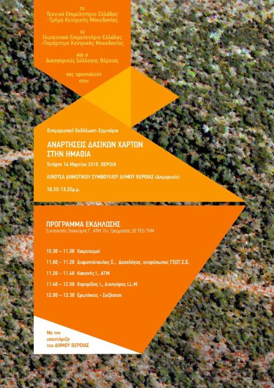
GEOTEE- Central Macedonia Branch in cooperation with TEE / TKM are organizing an information event - seminar on "Forest Map Posts in Imathia".

The event will take place in Veria on Wednesday, March 14, 2018, at the Town Hall in the Town Hall.

It is addressed to the members of both bodies but also to the Local Government and during it will be presented informative issues on the connection of cadastral registration with forest maps, clarifications on the postings, as well as legal issues on the status of objections etc. .Pi.

Posting of forest maps across the territory began on Friday, January 13th, covering 33 regions of the country, covering a total of 46.8 million acres.

- OMIKRON Environmental Consultants SA and GAIA EPICHEIRIN SA through the new "Agro-forest Land Advisory Service", it is with you on all the steps to keep you fully informed about your parcels as well as the effective handling of regulatory requirements.


The ' Agro-forest Land Advisory Service' application is an innovative and integrated service in the agricultural sector. The integration of this application into the regulatory process ensures the smooth and orderly operation of agricultural activity. We have collected the regulatory requirements of forestry legislation and adapted them so that each producer can receive personalized information, in order to safeguard his agricultural aid and agricultural land use. We have created a single, practical and integrated online application that, together with the support of specialized partners, will provide effective solutions to the Greek producer. We have implemented, through the application, simplification of information and identification procedures for potential problems with the characterization of parcels, while at the same time offering solutions for maintaining agricultural aid, with the aim and priority of sustainable farming.


For more information click here